Ma Pi Leng Pass Sky Path: Dong Van to Meo Vac on the Ha Giang Loop
A cliff-hugging road above an emerald river, limestone spires, and a short footpath that feels like flying. Ride or walk the Ma Pi Leng Pass between Dong Van and Meo Vac for northern Vietnam’s most dramatic route.
- The 22 km Dong Van–Meo Vac run includes Vietnam’s iconic Ma Pi Leng Pass and the optional “Sky Path” foot trail.
- Best light is early morning or late afternoon; expect fog in winter and sudden showers in summer.
- Permits are required for Ha Giang’s border districts; ride slowly, sound your horn on blind curves, and respect local villages.
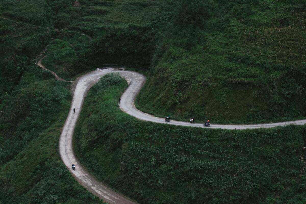
There are routes that earn their reputation in photographs, and then there’s Ma Pi Leng Pass—an asphalt thread slung across the ribs of northern Vietnam’s Dong Van Karst Plateau. Between the market towns of Dong Van and Meo Vac, the road clings to limestone walls as the Nho Que River carves a turquoise trench far below. Whether you’re riding a motorbike, hiring a driver, or stepping onto the narrow Sky Path foot trail that skitters above the void, this is a route that makes time slow and edges feel sharper. It’s both the high point of the Ha Giang Loop and a lesson in traveling with humility: every corner is shared, every viewpoint is earned, and every village has a rhythm that outlasts passing engines.
For travelers chasing a tangible sense of place, the Dong Van–Meo Vac segment offers density: geology stacked in cliffs and cones, a river glowing like blown glass, roadside stalls serving pho at altitude, H’Mong and Dao farmers walking switchbacks with baskets, and a borderland calm that somehow contains all of this. The distance is modest—about 22 kilometers—but the route is best measured in pauses, not kilometers.
| Quick Facts | Details |
|---|---|
| Route | Dong Van to Meo Vac via QL4C, with optional Sky Path foot trail above Ma Pi Leng Pass |
| Distance | Approximately 22 km (road); 1–2 km on the Sky Path (out-and-back, unpaved) |
| Elevation | Pass summit around 1,500 m; steep exposure above the Nho Que River |
| Travel Time | 45–90 minutes riding without detours; 3–6 hours with viewpoints, Sky Path walk, or boat trip |
| Best Season | September–November and March–May for clearer skies; December–February can be foggy and cold |
| Permit | Required for foreign travelers in Ha Giang’s border districts; obtain in Ha Giang City or checkpoints |
What Makes the Sky Path Special
The phrase “Sky Path” is used loosely in travel posts, but here it describes a narrow, sometimes crumbly foot trail etched into the limestone shelf above the main Ma Pi Leng roadway. It’s the place where the road’s drama distills into a few boot-widths of exposure. Looking down, you’ll trace the sinuous cut of the Nho Que River as it funnels into Tu San Canyon, often described as Vietnam’s deepest gorge. Looking across, you’ll see the karst mountains standing like a fossilized wave mid-crash, their ridges scalloped and the slopes ribbed with dry stone walls and corn terraces.
The Sky Path is not continuous; rather, short sections are accessed near marked viewpoints and roadside parking areas between the famous panoramic terrace and Pa Vi. Surfaces range from firm packed earth to rough rock steps. Guardrails are rare. The path is walkable in sturdy shoes for anyone comfortable around heights, but it’s not ideal for small children, sandals, or windy days. Step aside for others, go slow, and resist the urge to walk while filming; the most striking footage comes from stopping at safe pull-outs anyway.
On the main road, motorbikes outnumber cars by a wide margin. The route skates along cliff edges but is asphalted and generally in good condition, with the caveat that rockfall, spilled gravel, and narrow shoulders are normal. Horn etiquette matters. Tap your horn at the approach to blind hairpins. Expect trucks carrying construction materials and buses full of domestic travelers on weekends. Locals drive this road every day; ride like a guest.
Beyond scenery, the pass is a living corridor. H’Mong women in indigo skirts and bright collars walk the verges with woven baskets. Goats choose illogical crossing moments. Children wave from terraces of maize and flax. The street-level spectacle adds human scale to the enormous relief, reminding you this road doesn’t exist for tourism alone.
If you’re tempted by a water-level perspective, consider detouring for a short boat trip into Tu San Canyon from Ta Lang or Tu San boat stations below the pass. The ride lasts about an hour. On calm days the river is a milky emerald and the canyon walls rise as if freshly cut. Return to the pass in time for the late afternoon glow; the limestone takes on a brushed-bronze hue just before sunset.
- Viewpoints to mark on your offline map: Panorama Viewpoint (often signed), Ma Pi Leng Skywalk segment, Pa Vi Community Village terrace, and the Meo Vac side terraces.
- Do not fly drones near border posts or without permission; this is a sensitive frontier area.
- Carry small cash for roadside coffee, sunflower seeds, and parking at popular lookouts.
Photographers should plan for dynamic range: shadowed canyon floors and bright skies. A circular polarizer helps knock glare off the river; a lightweight tripod is useful for blue hour when the road’s curves start to glow with headlight trails. Even in dry months, keep a microfiber cloth handy—cliff spray and humidity are real.
Planning Your Day on the Pass
The simplest itinerary starts in Dong Van after sunrise. Fuel up, secure your permit documents in a dry bag, and check brake function and tire pressure. If you’re renting a motorbike, a semi-automatic 110–125cc is a smart, forgiving choice for beginners on mountain roads; experienced riders often prefer a manual 150cc. Pack a wind layer even in the warm season; wind at the passes can cut more than the temperature suggests.
Leave Dong Van on QL4C. The road climbs immediately, giving you a quick measure of gradient and corner radius. At roughly the halfway mark, the world opens. Limestone buttresses fold away and the river appears—small at first, then impossibly far below. Pull into the main panorama terrace and park well off the asphalt. Vendors here sell coffee, sugarcane juice, and instant noodles; the vantage is a natural place to calibrate exposure and nerves. From this point, you can pick up a segment of the Sky Path on foot. It’s an out-and-back stroll; even 15–20 minutes yields outrageous angles into the canyon.
Continue riding toward Pa Vi, a village folded into a broad terrace. For travelers who want to linger, Pa Vi Community Village offers homestays built in a heritage style, with stone walls and timber frames around a central square. Even if you don’t stay overnight, the terrace here provides an alternative perspective over the canyon, and a few coffee stalls serve strong, local arabica blends—ideal for an unhurried half-hour.
Past Pa Vi, the road threads through a series of tighter corners. Sound your horn before every blind turn. Oncoming trucks tend to ride the inside lines; give them their swing. Brake early and gently—especially if your bike is loaded with luggage. Pull-outs are frequent but small; never stop on a curve and always park on the mountain side where possible.
Approaching Meo Vac, keep an eye out for a sign pointing down to the river boat landing (routes vary; check current access conditions). If time allows, the boat trip is a radically different viewpoint on the same geography. From river level, the road is invisible and the canyon walls rise in sheets. On weekends, expect waits for boats; on weekdays, rides may cluster around noon and mid-afternoon.
Markets anchor life in both towns. Dong Van’s Sunday Market is legendary, with H’Mong, Tay, and Dao families arriving before dawn to trade pigs, herbs, cloth, and stories. Meo Vac hosts its own Sunday bustle, a feast for the senses and a reminder that this route is stitched into a wider weekly choreography. If your schedule is flexible, time your pass day to arrive Saturday evening, sleep in Dong Van, and ride the pass early before circling back into the market commotion.
Weather can flip your plan. In winter months (December–February), the pass often wakes in fog. If visibility is low, consider delaying departure until late morning when the light burns through. In the wet season (roughly May–September), noon showers are common; a late-afternoon window can bring sparkling post-rain clarity. Either way, build slack into your day. A route this short deserves several hours of attention.
Reasonable average speeds on the pass hover around 20–35 km/h for cautious riders. Anything faster sacrifices the very point of being here. If you’re new to mountain riding, use engine braking: downshift before the descent, avoid riding the brakes, and give yourself margin at all times. If conditions or confidence waver, remember that hiring a car and driver is straightforward in Dong Van and Meo Vac. Sitting high in a van’s window seat is not a lesser experience; it’s just a different cadence.
- Micro-itinerary: Dong Van espresso and banh mi; Ma Pi Leng panorama stop; Sky Path walk; coffee at Pa Vi; optional boat trip; golden-hour ride into Meo Vac.
- Short detour: From Meo Vac, a side ride to Xin Cai reveals quieter terraces and boulder fields with fewer crowds.
- Food tips: Try thắng cố in market stalls if you’re adventurous; otherwise pho, grilled pork skewers, and sticky rice are reliable standbys.
Logistics, Safety, and Local Etiquette
Permits first. Ha Giang’s border districts require a travel permit for foreigners. You can obtain it through your hotel or a tour agency in Ha Giang City (often issued at the Immigration Office) or at police checkpoints in towns like Yen Minh and Tam Son. Keep a photo and paper copy on hand; you may be asked to show it at random stops. Riding without a permit risks fines and delays.
Insurance matters. Many rental shops offer basic coverage that excludes off-road damage and often most damage. Confirm what’s covered and consider your own travel policy for medical evacuation. Helmets are mandatory—bring or request a quality full-face or three-quarter helmet rather than the decorative half-shells some shops hand out. Gloves, a windproof jacket, and closed shoes are the baseline; armored gear is better.
Fuel and cash are simple, just not everywhere. Fill up in Dong Van before departure; small roadside petrol stands do exist, but they close unpredictably. ATMs are available in Dong Van and Meo Vac, but card acceptance is rare at homestays and cafes along the pass. Carry small notes and keep some emergency cash separate from your wallet.
Connectivity is improving but patchy in the canyon. Download offline maps (Google Maps, Maps.me, or OSMAnd). If you need a local SIM, pick one up in Ha Giang City. Power banks are handy; a mid-day top-up at a cafe is not always possible. Keep emergency contacts for your hotel and rental shop saved. In the unlikely event of a breakdown, stay visible, move off the road, and ask passing riders to notify the nearest town.
Weather and road conditions are the X-factors. After heavy rain, small landslides and gravel patches appear. Treat any shaded corner as suspect for moisture and moss. In cold snaps, temperatures at the pass can dip into single digits Celsius; fog creates condensation on lenses and mirrors. A cheap clear visor insert or anti-fog spray helps. If lightning is active, do not linger on the Sky Path—get back to the road and wait it out at a sheltered stall.
Culture runs deeper than views. The H’Mong, Tay, and Dao communities have shaped the terraced fields and stonework for generations. Ask before photographing people, especially children. A small purchase from a vendor who agrees to a portrait is a respectful exchange, but never push. Do not hand out sweets or money to kids; it encourages roadside solicitation. If you want to support communities, consider staying in a family-run homestay, hiring a local guide for the Sky Path, or buying handwoven textiles directly at markets.
Environmental respect is non-negotiable. Pack out trash, including tissues and cigarette butts. Use toilets at cafes rather than the roadside. Stick to established paths on the Sky Path; new social trails erode quickly in the limestone scrub. If you smoke, step well away from dry grass and carry a pocket ash container. Sound carries in the canyon—keep music low and engines idling only as long as necessary.
Border awareness is part of traveling here. You’re close to China, and certain ridgelines host military or border observation posts. Avoid pointing cameras at facilities or personnel. Drones are restricted; if in doubt, don’t launch. Check current guidance with your homestay.
- Pack list for the pass: windbreaker, light gloves, water, snacks, headlamp (for late returns), microfiber cloth, sunscreen, cash, permit copies, portable charger, and a compact rain shell.
- Rider’s checklist: horn works, brakes bite evenly, mirrors adjusted, tires properly inflated, chain tension reasonable, lights functional.
- Etiquette essentials: slow for livestock, yield to trucks and buses, greet villagers with a smile or “Xin chào,” and keep viewpoints tidy.
Not necessarily, but you do need comfort with steep, narrow mountain roads and tight switchbacks. Many first-timers manage the pass on a semi-automatic if they ride conservatively, avoid peak traffic hours, and stop often. If in doubt, hire a local driver and enjoy the route from the passenger seat, then walk the Sky Path on foot.
Not necessarily, but you do need comfort with steep, narrow mountain roads and tight switchbacks. Many first-timers manage the pass on a semi-automatic if they ride conservatively, avoid peak traffic hours, and stop often. If in doubt, hire a local driver and enjoy the route from the passenger seat, then walk the Sky Path on foot.
There are several access points along the pass. The most common begins near the main panorama terrace on the Dong Van side, where informal parking and vendors gather. Ask a vendor to point out the “lối đi bộ” (walking path). Surfaces and conditions change with weather and repairs, so proceed cautiously and turn back if it feels unsafe.
There are several access points along the pass. The most common begins near the main panorama terrace on the Dong Van side, where informal parking and vendors gather. Ask a vendor to point out the “lối đi bộ” (walking path). Surfaces and conditions change with weather and repairs, so proceed cautiously and turn back if it feels unsafe.
Its color varies with season and flow. In the dry months it often appears milky emerald, especially under polarized light. After heavy rain it can turn a deeper jade or brownish from sediment. Either way, the contrast with black karst walls remains striking.
Its color varies with season and flow. In the dry months it often appears milky emerald, especially under polarized light. After heavy rain it can turn a deeper jade or brownish from sediment. Either way, the contrast with black karst walls remains striking.
Yes, many travelers with mild height anxiety manage fine in a car. If riding, focus on the lane ahead rather than the drop-offs, and stop only at viewpoints where you feel secure. Skip the Sky Path if exposure triggers vertigo; the road’s viewpoints offer ample drama without stepping onto ledges.
Yes, many travelers with mild height anxiety manage fine in a car. If riding, focus on the lane ahead rather than the drop-offs, and stop only at viewpoints where you feel secure. Skip the Sky Path if exposure triggers vertigo; the road’s viewpoints offer ample drama without stepping onto ledges.
Start early on weekdays. Tour groups tend to cluster mid-morning to mid-afternoon. Arrive at the panorama terrace shortly after sunrise or during the last hour of daylight for thinner crowds and softer light. Walk a little further along the Sky Path than the first bend—most people stop early.
Start early on weekdays. Tour groups tend to cluster mid-morning to mid-afternoon. Arrive at the panorama terrace shortly after sunrise or during the last hour of daylight for thinner crowds and softer light. Walk a little further along the Sky Path than the first bend—most people stop early.
Ultimately, the Dong Van–Meo Vac run is a concentrated masterclass in route design carved by necessity and shaped by stone. It’s the embodiment of a “destination is the journey” cliché that turns out to be true once you’re there, hearing your own heartbeat in your helmet at a cliff’s edge, sipping hot tea above a cold river, and waving back at a child whose walk home zigzags across the same switchbacks you just negotiated. If you give it time, the pass will give you space—a rare trade on any road.