Iceland’s Westfjords Way: A 950 km Loop Through Puffin Cliffs and Geothermal Shores
Trace a newly waymarked loop around Iceland’s Westfjords, where cliff-edge roads, red-sand beaches, quiet fishing towns, and hot spring pools make every bend of the 950 km Westfjords Way feel like a discovery.
- Drive a 950 km signed loop linking Iceland’s most remote fjords, villages, and hot springs
- See marquee stops like Látrabjarg puffin cliffs, Rauðasandur beach, Dynjandi waterfall
- Plan for mixed paving, changing weather, single-lane tunnels, and sparse services
The Westfjords Way, known locally as Vestfjarðaleiðin, is a 950 kilometer driving loop that stitches together Iceland’s least-populated peninsula with a string of fjords, bird cliffs, quiet harbors, and geothermal pools. Launched as a dedicated route with fresh signage and traveler services in recent years, it gives structure to a wild corner of the country that long felt like the edge of the map. If you’ve already ticked off the Ring Road or you’re choosing one region to dive into deeply, this circuit delivers cliff-top drama and soft, slow-travel texture in the same trip.
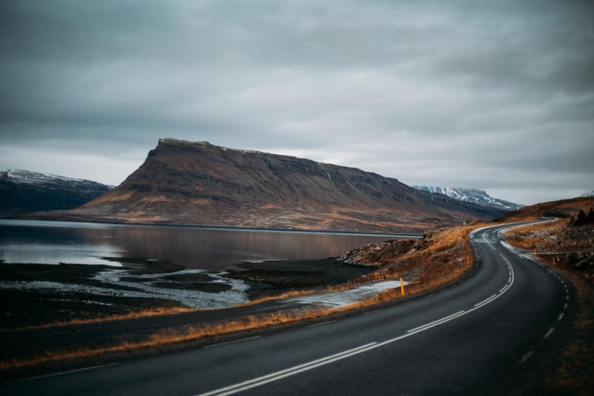
Unlike many famous road trips, the Westfjords Way isn’t about one scenic pass or a single highlight. It’s a rhythm: watery commas of fjords, sleepy towns, sudden tunnels, yellow-signed blind rises, and frequent urges to pull over for sheep, seals, or a sunburst over a slate-blue bay. You’ll spend time in places like Ísafjörður, Patreksfjörður, and Hólmavík, but the best moments often happen between them—at a lay-by with a view to nowhere, or on a gravel spur that ends at a steaming pool on the shoreline.
Make no mistake: this is still the remote Iceland many travelers crave. Services are spaced out, weather has opinions, and a side road that looks short can take longer than you expect. But that’s part of the appeal. The Westfjords Way gives you a loop you can follow—and color in as boldly or as lightly as you like.
Why the Westfjords Way Is Different
First, it’s new as a unified route. The roads have existed for decades, of course, but they’ve been pulled into a clear narrative with maps, waymarks, and itineraries that make planning less guesswork-y. That means you can think in segments and days rather than just squinting at a tangle of fjords and hoping for the best. Crucially, some infrastructure has been upgraded too: the Dýrafjarðargöng tunnel now ties fjords together in all but the worst winter weather, and sections of Route 60 are smoother than they used to be. Still, drivers should anticipate a mix of paved and gravel surfaces.
Second, it’s a loop that rewards lingering. You don’t blast from Point A to Point B. You drift—along Route 61 into Ísafjörður under the jagged ramparts of mountains, around Arnarfjörður to the bridal-veil tiers of Dynjandi waterfall, out toward the peninsula tip to the seabird stronghold of Látrabjarg, and back along Strandir’s moody coast where pools like Krossneslaug steam at the literal edge of the Arctic waters. It’s a route that whispers: slow down.
Third, the Westfjords Way is a birders’, soakers’, and photographers’ feast. In summer, puffins pose for portraits at arm’s length on grassy cliff edges; seals lounge on skerries; guillemots and kittiwakes fill the air like confetti. Dynjandi is one of Iceland’s most elegant falls, and Rauðasandur beach proves that Iceland’s palette includes red—an almost Saharan swath of sand framed by cold Atlantic and green headlands.
How to Drive It: Segments, Timing, and Road Tips
Most travelers enter the loop from the south via Route 60, branching off the Ring Road. You can drive clockwise or counterclockwise; both flow nicely. Counterclockwise gets you to the Westfjords’ big-ticket items—Dynjandi, Rauðasandur, and Látrabjarg—earlier, which can be satisfying on shorter trips.
Allow four to seven days depending on how many hikes, hot springs, and boat tours you fold in. Two days is too rushed unless you’re only sampling one arm of the loop. If you plan to include Strandir (the east coast facing the Greenland Sea) and the far-flung pool at Krossneslaug, build in an extra day—those kilometers take time.
To get your head around distances and services, here’s a simple segment overview. Distances and drive times are approximate and assume summer conditions.
| Segment | Km | Typical Drive Time | Fuel & Food Notes | Highlights |
|---|---|---|---|---|
| Ring Road (near Bifröst) to Hólmavík (via Route 60/61) | 200 | 3–3.5 hrs | Fuel at Bifröst, Hólmavík; food in Hólmavík | Gravel switchbacks, sorcery museum, Drangsnes hot pots |
| Hólmavík to Ísafjörður (Route 61) | 230 | 3.5–4.5 hrs | Fuel at Hólmavík, Súðavík, Ísafjörður | Arctic Fox Center, long fjord drives, tunnels |
| Ísafjörður to Þingeyri & Dynjandi (Route 60 via tunnels) | 100 | 1.5–2.5 hrs | Fuel at Ísafjörður, Þingeyri | Vestfjarðagöng tunnels, coastal views, Dynjandi hike |
| Dynjandi to Patreksfjörður & Rauðasandur (Routes 60/62) | 120 | 2–3 hrs | Fuel at Patreksfjörður; limited on Rauðasandur spur | Red-sand beach, sea arches, viewpoints |
| Patreksfjörður to Látrabjarg & back (Route 612 spur) | 80–110 | 2–4 hrs | No services; bring snacks | Puffin cliffs, lighthouse, coastal gravel |
| Patreksfjörður to Ring Road (Route 60 south exit) | 260 | 4–5 hrs | Fuel at Bíldudalur, Flókalundur | Hellulaug hot pool, Breiðafjörður views |
Road quality varies. Primary links like 60 and 61 are mostly paved with some gravel patches, while spurs to Rauðasandur and Látrabjarg include lengthy gravel stretches with washboarding. Drive by sight lines, be gentle on brakes, and yield on single-lane bridges and in narrow tunnels. In summer, any standard rental car works for the main route; a higher-clearance vehicle is more comfortable on washboard gravel. In shoulder seasons, check road.is for conditions and closures.
Don’t underestimate time. The distance “as the puffin flies” across a fjord can be six kilometers; the road around it might be 60. And sheep wander—when you see two on the verge, assume a third is about to step out. Speaking of animals, Arctic foxes sometimes cross low in the evening light; go slow and enjoy the encounter.
EVs are increasingly viable. Chargers exist in Ísafjörður, Hólmavík, Patreksfjörður, and a handful of other towns; plan legs thoughtfully and top up whenever you stop. Charge cards and apps can be spotty; have a backup card and allow time buffers.
Stops You Shouldn’t Miss
Dynjandi: A scalloped cascade dropping 100 meters in bridal veils. From the parking area, a well-marked trail climbs past smaller falls to the broad main fan. Allow an hour to wander and photograph; the scale sneaks up on you as you climb and the sound becomes a presence. Go early or late for gentler light and fewer people.
Látrabjarg: One of Europe’s largest bird cliffs and a puffin paradise in summer. The gravel approach (Route 612) is worth the slow roll. At the cliff, stay well back from the edge—burrows undercut the turf. Puffins are calm; you don’t need a giant lens. Kneel, keep movements slow, and you’ll be rewarded with eye-level portraits and curious head tilts.
Rauðasandur: A red-gold beach that contradicts every cliché about Iceland’s black sands. The color comes from pulverized scallop shells and iron-rich minerals. If the tide’s low, the wet mirror stretches to the horizon, reflecting cloud stacks like a painting. There’s a small café in season; pack out what you bring in.
Hellulaug: A stone-rimmed hot pool right on the shore near Flókalundur. It’s informal, free, and photogenic—best at high tide when waves breathe close by. Rinse before soaking if you can, respect fellow bathers’ quiet, and keep glass away from the pool edge.
Ísafjörður: The Westfjords’ informal capital. It’s a fine base for sea kayaking among sheltering fjords, boat trips to Vigur Island (eider down heritage, puffins, and a tiny post office), and hearty meals of fish soup, plokkfiskur, or Arctic char. The heritage houses near the harbor make a pretty evening stroll.
Súðavík and the Arctic Fox Center: A small but delightful stop to learn about Iceland’s only native mammal. Exhibits cover the fox’s ecology and fur-trapping history, and you’ll leave seeing the tundra differently.
Strandir Coast: The east edge of the Westfjords is lonelier than the south and west arms. Hólmavík’s Museum of Sorcery & Witchcraft rummages through sagas of magic and marginal survival; northward, roadside pools at Drangsnes overlook seal-studded skerries, and further still, Krossneslaug’s concrete basin sits at the literal edge of the sea. If you want to feel small in the best way, soak there at midnight in July.
Patreksfjörður and Bíldudalur: Friendly harbors with understated charm. Grab a coffee, walk the quays, and chat with locals about weather windows, fishing, and where the whales have been this week. In summer, a few food trucks and pop-up bakeries appear; don’t pass the kleina or cinnamon buns.
For planners, here’s a sample 5-day loop that keeps daily drives modest and includes time to explore on foot and in hot water:
- Day 1: Ring Road to Hólmavík. Stop at Grábrók crater, then roll into Strandir. Evening soak at Drangsnes hot pots; dinner in Hólmavík.
- Day 2: Hólmavík to Ísafjörður. Arctic Fox Center stop, tunnels, fjord photo breaks. Kayak or museum in the evening.
- Day 3: Ísafjörður to Dynjandi to Þingeyri. Long lunch, easy hike at Dynjandi. Sunset walk on the black-sand spit by Þingeyri.
- Day 4: Þingeyri to Patreksfjörður. Detour to Rauðasandur. Late-day drive to Látrabjarg for golden-hour puffins; return to Patreksfjörður.
- Day 5: Patreksfjörður to Flókalundur (Hellulaug soak), then south out of the fjords back to the Ring Road.
If time allows, bolt on an extra day to venture up Strandir to Krossneslaug or to join a boat tour out of Ísafjörður to Hornstrandir Nature Reserve (no roads—pure wilderness).
Practicalities can make or break a remote-road trip. Consider these essentials:
- Fuel early, fuel often. Don’t dip below half a tank before committing to a spur like Route 612 or 614.
- Respect single-lane protocols. At bridges, whoever arrives first goes first; in tunnels with pull-outs, yield to oncoming traffic if your direction has lay-bys.
- Watch the wind. Car doors are vulnerable. Hold them with two hands when opening.
- Gravel etiquette: slow for passing cars to reduce chips; keep plenty of following distance.
- Sheep are unpredictable; lambs will follow ewes—often after you think the road is clear.
Accommodations range from guesthouses and farm stays to simple hotels and a few campsites with stellar views. Book early for June–August. In shoulder seasons, call ahead even if booking pages look open—some places open only on demand.
Eating well is part of the fun. Order fish of the day; ask about blue mussels, cod cheeks, or halibut. Try rúgbrauð (dense rye) with butter, and seek out kleinur (twisted doughnuts) in small-town bakeries. Coffee culture is strong; even tiny stations pull decent espresso now.
Photography tips: For cliffs and birds, a short tele (70–200mm) is plenty. For wide fjordscapes, go 16–24mm. Bring a microfiber cloth; sea spray is sneaky. Polarizing filters tame glare on water and wet sand, especially at Rauðasandur. Golden hour lasts a long time at high latitude—use it to thread gravel spurs with soft light.
Drones are tempting, but check local regulations and signage. Many bird cliffs are no-drone zones in nesting season. If you fly, launch well away from wildlife and people and keep line-of-sight at all times. The natural soundscape here—wind, water, wings—is part of the place; don’t drown it out.
Seasonality shapes the experience. In high summer, you get long light, passable gravel, and lively villages. In spring and autumn, colors deepen, but storms grow feistier; some high routes can close, and services taper. Winter can be magical in clear spells but requires local knowledge, flexible plans, studded tires, and acceptance that closures can strand you. If your Westfjords dreams involve snowy peaks and empty roads, consider a guided winter itinerary.
Traveling responsibly matters in fragile landscapes. Park only in pull-offs, avoid driving on vegetation, stick to established tracks, and pack out all trash. At hot pools, keep soap out of natural water and change discreetly; a lightweight poncho makes trailhead changes easier and more modest.
Budget-wise, gas and food are the big line items. Save by self-catering some meals, choosing guesthouses with breakfast included, and using town swimming pools (which often include hot tubs and saunas) for a few dollars instead of pricier private baths. Splurge on one signature experience—sea kayaking, a guided cliff walk, or a rib-boat wildlife tour—and let the rest be simple pleasures.
If you’re stitching the Westfjords Way into a larger Iceland trip, consider the Baldur ferry across Breiðafjörður between Brjánslækur (near Flókalundur) and Stykkishólmur on the Snæfellsnes Peninsula. It’s a scenic shortcut that saves backtracking and opens another classic coastal drive, weather permitting. Book ahead and factor in seas; wind can alter schedules.
Finally, a mindset note: the Westfjords reward flexibility. Clouds can shroud a cliff one hour and lift the next. A café might be closed, but the view from a picnic bench could be perfect. Let the loop offer options, not obligations. If a side road calls you toward a cove with no name on your map, that’s often where the day’s best memory waits.
No for summer on the main loop: standard cars are fine with careful driving. Yes for some rough spurs and in shoulder seasons when conditions deteriorate. Always check road.is before committing to gravel side routes.
No for summer on the main loop: standard cars are fine with careful driving. Yes for some rough spurs and in shoulder seasons when conditions deteriorate. Always check road.is before committing to gravel side routes.
Typically from late May through mid-August, with peak activity in June–July. Go early morning or late evening for calmer crowds and softer light. Stay behind cliff-edge safety lines and tread lightly to protect burrows.
Typically from late May through mid-August, with peak activity in June–July. Go early morning or late evening for calmer crowds and softer light. Stay behind cliff-edge safety lines and tread lightly to protect burrows.
Yes, if you keep driving days reasonable and build in frequent stops—waterfalls, hot pools, beach walks, and wildlife lookouts. Pack snacks, layers, and a flexible schedule. Watch kids closely near cliffs and on gravel roads.
Yes, if you keep driving days reasonable and build in frequent stops—waterfalls, hot pools, beach walks, and wildlife lookouts. Pack snacks, layers, and a flexible schedule. Watch kids closely near cliffs and on gravel roads.
Use established campsites where available; they offer showers and kitchens. Wild camping rules are strict and vary by landowner and municipality. When in doubt, ask locally and avoid sensitive coastal vegetation.
Use established campsites where available; they offer showers and kitchens. Wild camping rules are strict and vary by landowner and municipality. When in doubt, ask locally and avoid sensitive coastal vegetation.
The Westfjords Way works because it hands you a frame—and then invites you to color outside the lines. Whether you’re here for cliffside bird colonies, steaming pools at the sea’s edge, or the simple contentment of driving into the blue on a quiet road, this loop gives you room to find your own pace. Bring layers, curiosity, and time. The rest will reveal itself, one fjord at a time.