Into the Moulins: Explorers Mapping Greenland’s Hidden Ice Rivers with Drones and Rope
A small team of rope specialists, glaciologists, and drone pilots is descending into Greenland’s moulins—vertical shafts in the ice—to map the roaring blue rivers that shape the fate of the ice sheet.
- Moulins are vertical shafts draining meltwater through glaciers; exploring them reveals how ice sheets lose mass.
- Hybrid expeditions use rope systems and autonomous drones to map dangerous passages without risking full descent.
- High-resolution models from photogrammetry are reshaping melt models and safety protocols for polar travel.
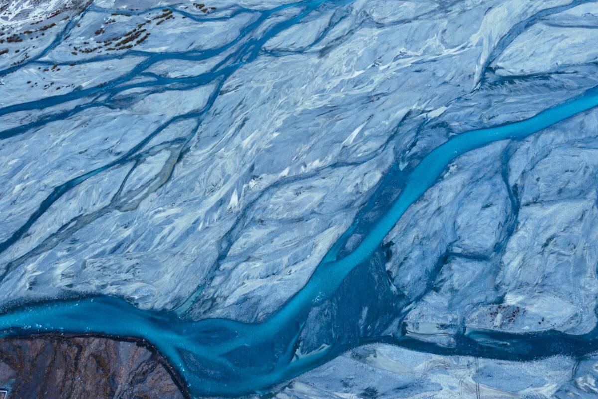
On a wind-etched summer afternoon in western Greenland, a group of explorers stands beside a portal into another world. The opening—ragged, cerulean, bottomless to the naked eye—gargles with meltwater as it disappears into the glacier. This is a moulin: a vertical shaft in the ice carved by surface streams and warmed by friction, a drainpipe for the ice sheet that hustles water to its belly. For decades, moulins were a rumor of the polar field journals, a muffled thunder beneath the boots of scientists. Today, a new breed of explorers—part rope technician, part scientist, part aerial roboticist—steps to the edge with coils of static line, carbon-fiber drones, and a plan to go down.
Their objective is as simple as it is audacious: create the first high-resolution, navigable models of active moulins while they are alive with water. To do that, they mix techniques from cave diving, alpine rigging, and cinematic drone work. The result is a growing archive of three-dimensional maps and time-synced flow measurements that help disentangle one of the most consequential unknowns in cryospheric science: where, exactly, does the melt go—and how fast?
What Makes a Moulin an Explorer’s Obsession
To stand at the lip of a moulin is to feel the scale of a glacier’s plumbing system. Surface streams—the bright blue rivers that meander across summer ice—converge into sinkholes that yawn without warning. Once inside, the water scours and polishes the ice walls, sometimes corkscrewing through constrictions into caverns, sometimes dropping completely vertical like a frozen cathedral spire. The shapes are impermanent. One storm can change them; one heat wave can erase them. That constant reinvention makes moulins notoriously difficult to study—and irresistible to explorers tasked with revealing their secrets before the geometry shifts yet again.
Traditional scientific methods struggle here. Instruments balk at the cold and spray. Radios can’t penetrate the depth. Safety protocols forbid people from committing to passages that can pinch and flood in minutes. The compromise is an expeditionary choreography: anchor systems on the surface, a limited number of carefully managed descents to the safe zones, and a fleet of drones that do most of the wandering, beaming back position-tagged imagery.
While caves made of rock evolve over millennia, ice caves can recast themselves in a day. The explorers must treat every moulin like a brand-new planet. That means fresh anchors, fresh maps, fresh assumptions—and a mindset that accepts retreat as success when the glacier says no.
How They Do It: Rope, Drones, and a Frozen Orchestra
Successful moulin exploration is less a single descent than a symphony of roles. The expedition lead reads the weather and melt forecast, then decides if the team will approach dawn or dusk—cooler hours mean slower flow and more stable walls. Rigging specialists drill ice screws and place V-threads, equalizing multiple points to avoid shock loads if an anchor melts. A belay operator manages the rope, which is bagged to prevent the river from snagging coils. A communications tech strings a thinline of fiber or sets up a relay of line-of-sight radios, perched like sentinels around the lip. Finally, the drone pilots unpack machines that look like insects forged from LEGO and lightning.
It begins with preliminary imaging. A small reconnaissance drone, often a sub-250-gram craft bristling with LED strobe lights, peeks over the rim. The pilot dips the drone into the dark and lets its downward-facing sensors and sonar negotiate the spray. If the machine returns without icing over, the green light glows; if not, the team adjusts flight patterns or waits for temperatures to shift.
Next comes the mapping run. A larger drone, fitted with a high dynamic range camera and sometimes a compact LiDAR unit, flies slow arcs down the shaft. The path is pre-programmed to ensure proper overlap—80% or more—so photogrammetry software can stitch photos into a dense 3D point cloud. The pilot nudges the craft with micro-inputs while a safety operator watches battery levels, signal strength, and air temperature. The drone’s lights—green, white, red—become the only stars in a noon-day night.
Once the primary shaft is modeled, a human descender may go partway. This isn’t a stunt; it’s an instrument delivery. A researcher on rope clips watertight loggers onto the walls: temperature, turbidity, micro-pressure sensors that sample the thrum of the water column. They do this only in sections with broad stances and visible runout—places where the river widens into a bowl, not where it tightens like a fist. Every move is rehearsed on dry ice or crevasse practice sites days earlier.
| Tool | Role in the Moulin | Notes |
|---|---|---|
| Static rope (10–10.5 mm) | Main descent and haul line | Low stretch to prevent bounce; bagged to avoid water entanglement |
| Ice screws & V-thread anchors | Primary and backup anchor systems | Triply redundant; inspected every 30 minutes in sun |
| Sub-250 g drone | Reconnaissance and airflow testing | Less mass, less risk; stronger against icing with prop guards |
| HDR camera drone / LiDAR | Mapping and photogrammetry | Pre-programmed flight arcs; high overlap imagery |
| Data loggers (temp/pressure) | Flow dynamics and melt monitoring | Clipped on ice screws or stainless pins at safe ledges |
| Drysuit & insulated harness | Human descents in splash zones | Buoyancy counterweighted; anti-freeze boot liners |
After flights, the team ducks into a wind shelter and begins the rapid processing ritual. Millions of pixels are culled into a sparse point cloud, refined into a mesh, and finally rendered into a textured shell of the moulin. The first time a complete model resolves, there’s a hush: the impossible just became navigable. Researchers annotate choke points, eddies, and scalloped walls that reveal flow direction. The rope team overlays anchor positions, marking any zones that have warmed or slumped since rigging. On the next sortie, those notes guide exactly where to fly, where to place sensors, and where not to linger.
Why This Matters Now
Moulins are more than curiosities; they are express lanes from the surface to the bed of the ice sheet. Once water reaches the base, it can lubricate the contact between rock and ice, hastening glaciers toward the sea. But not all water behaves the same, and not all moulins stay open. Some chug steadily, others pulse—a function of surface temperature, rainfall, snow bridges, and the geometry of hidden conduits. Without ground-truthed maps, models can only guess. The explorers’ data gives those models bones.
In the last few summers, viral clips of drone lights spiraling down blue throats of ice pulled the public into the story. The trendline isn’t just visual spectacle; it’s a surge in “adventure science,” where specialists borrow the skills and tools of extreme sports to go where instruments alone can’t. That’s not a replacement for satellites and weather stations—it’s a way to stitch scales together, connecting the bird’s-eye with the boot’s-edge and the propeller’s path.
Beyond climate implications, there’s practical relevance for anyone traveling on glaciers. Expedition leaders draft safer routes when they understand where surface rivers tend to collapse. Search-and-rescue teams can brief pilots and ground crews about the acoustic signature of nearby shafts and the likelihood of undercut snow bridges. Even adventure tour companies adopt elements of moulin protocol—redundant anchors, edge guards, rope-bag discipline—when supervising clients near crevasse fields, where an unassuming slump can hide a blue mouth.
Greenlandic communities, whose knowledge of the ice’s moods predates science by centuries, have become essential partners. Guides from coastal towns know when katabatic winds are likely to surge as evening falls, or how fog pools along certain fjords before sunrise. Their input can mean the difference between a perfect mapping window and a weather trap. In exchange, the explorers share 3D models and safety workshops for local travel on summer ice, translating abstract geometry into practical decisions for hunters and fishers crossing melt zones.
As the work matures, the data arcs into policy. Scientists fold moulin geometries into projections of ice-sheet runoff. Municipal planners on distant coastlines weigh that runoff in sea-level rise forecasts that govern seawalls and floodplains. What began as an exploration of a bright blue hole becomes a footprint on the budget line of a city an ocean away. The path is indirect but real; exploration leaves marks in places the explorers may never see.
Inside a Typical Day on the Edge
04:15 – The team wakes to the percussion of meltwater beneath the camp floor. Coffee is rationed; batteries are not. A solar array angled at the oblique sun tops up packs of lithium cells. The forecast shows a temperature dip at 06:00—prime.
05:30 – Scout skiers flag the approach. They probe for weakness, zigzagging to avoid linear depressions that hint at subsurface channels. At the rim, a low murmur: the moulin talks. The riggers unpack long ice screws and test the upper layer for brittleness. If the first two placements fracture easily, they move laterally to find denser, older ice with smaller air bubbles.
06:20 – The recon drone flies. It returns slick with mist but responsive. Its camera captured the first 40 meters, a series of bulbous chambers spiraling clockwise. The team notes airflow strong enough to buffet; they adjust to a slower descent rate and boost LED power for texture in the photos.
07:10 – Mapping begins. The pilot flies concentric ellipses, dropping two meters per loop. The software calls out, “Overlap 86%.” Twenty minutes later, the drone emerges with 29% battery and a necklace of hoarfrost along the arms. It lands to cheers that sound like exhalations.
07:40 – A researcher clips in for a controlled drop to the first landing. The belay hums. At the ledge, they scrape a patch of ice smooth and mount a temp-pressure logger. It ticks once every ten seconds, a heartbeat buried in the roar. On the ascent, they stop to photograph a scalloped wall—evidence of turbulent flow.
09:00 – Inside the shelter, the model blooms on a laptop. The shaft’s twists are not random; each pinch coincides with a layer of windblown dust trapped in the ice decades ago. Those layers melt differently, carving the current pattern. The alignment of anchors is revised based on strain calculations from the model’s measurements of wall curvature.
11:30 – The wind rises and the melt accelerates, turning the clean blue into a frothier white. The team halts operations. Retreat is not a failure; it is the discipline that ensures there will be a next day.
Lessons and Evolutions in the Craft
The explorers’ methods are iterative, governed by the glacier’s feedback. Early flights lost to icing taught them to pre-warm batteries in insulated pouches and to use hydrophobic coatings on propeller leading edges. A near-miss with a rope snag led to mandatory use of rope bags and an “edge marshal” whose sole job is to keep lines clear of the lip. The discovery that radio signals attenuate rapidly through dense spray convinced them to string temporary repeaters along snow stakes, building a daisy chain of connectivity.
They learned to distrust sunny days. Beauty belies risk; radiant heat gnaws at anchor integrity and swells flow rate. Cloud cover and a cold breeze—unphotogenic conditions—often deliver the best mapping windows. They also learned to value silence. The moulin’s roar isn’t constant; when the tone drops, a blockage may be forming. That’s a cue to pull drones up, fast.
Even the way they narrate the work has matured. Early media focused on the daredevil angle—hovering machines over bottomless pits. Now, the explorers frame moulins as dynamic systems. Images of spiraling light are paired with cross-sections of flow velocity. In field schools, they teach micro-skills—how to coil a rope that won’t kink when cold, how to evaluate ice with a hammer’s tap, how to fly a drone by listening to its props when the wall steals GPS lock.
Where they go next depends on the ice and on technology’s march. Compact radar that can ride a drone may soon add subsurface hints to the models. Lightweight winches with regenerative braking could reclaim energy on hauls. Machine learning already accelerates the photogrammetry pipeline, finding tie points in featureless ice more readily than human-tuned software. But the core alchemy will remain: curiosity, caution, and the kind of patience that accepts an entire season of reconnaissance for a single hour of perfect flight.
FAQ
Direct human descents are rare and limited to short, low-risk sections with multiple redundant protections. Most exploration is done by drones to minimize exposure to cold shock, sudden surges, and wall collapse.
Direct human descents are rare and limited to short, low-risk sections with multiple redundant protections. Most exploration is done by drones to minimize exposure to cold shock, sudden surges, and wall collapse.
Models quantify shape, volume, and change over time. They allow measurements of wall scalloping, constrictions, and cross-sectional area—variables that feed into flow-rate estimates and glacier hydrology models.
Models quantify shape, volume, and change over time. They allow measurements of wall scalloping, constrictions, and cross-sectional area—variables that feed into flow-rate estimates and glacier hydrology models.
Tethers snag in complex ice geometry and can be pulled by water. Free-flying drones maneuver in tight spaces, retreat quickly, and carry sufficient sensors at low weight. Where tethered bots excel—long endurance—drones compensate with rapid sorties.
Tethers snag in complex ice geometry and can be pulled by water. Free-flying drones maneuver in tight spaces, retreat quickly, and carry sufficient sensors at low weight. Where tethered bots excel—long endurance—drones compensate with rapid sorties.
Greenlandic guides contribute route selection, weather timing, and risk signals drawn from generations on the ice. Their insights calibrate models with on-the-ground reality and help avoid known hazard zones.
Greenlandic guides contribute route selection, weather timing, and risk signals drawn from generations on the ice. Their insights calibrate models with on-the-ground reality and help avoid known hazard zones.
In the end, the explorers leave with drives of data and a lingering hum in their bones. They will return when the cold returns, when the sun is low and the water’s voice softens. The moulin they mapped this year will not be the moulin they find next year. That impermanence is the challenge and the charm: a disappearing labyrinth that yields its shape only to those patient enough to listen—and quick enough to look before the ice writes a new story.