Rescuing the Last Tropical Ice: The Puncak Jaya Core Retrieval Expedition
An international team ascends Papua’s highest peak to drill and preserve the last tropical ice cores before they vanish, turning a perilous climb into a mission to safeguard centuries of climate memory.
- Tropical glacier ice preserves rare, year-round climate signals now disappearing at record speed.
- A high-altitude drill team will extract cores and ship them to a long-term cold archive for future research.
- Indigenous partnerships, helicopter logistics, and compact tech make the expedition possible under tight weather windows.
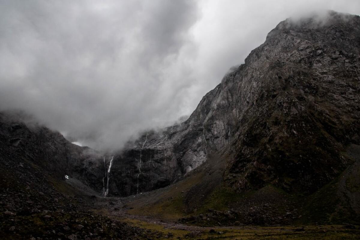
High on the limestone spine of New Guinea, a ragged fringe of white clings to sawtooth ridges and karst towers. This is the remnant ice of Puncak Jaya—also known as Carstensz Pyramid—the highest peak of Oceania and one of the world’s last tropical glacier strongholds. In a warming climate, these patches are shrinking by the season. A small window remains to retrieve ice cores—layered cylinders of ancient snow turned to ice—that can lock away centuries of tropical climate history before it melts into the clouds. The expedition outlined here is as much a rescue as it is a climb.
Unlike polar ice, tropical glacier ice captures signals from year-round convection, sea-surface temperatures, wildfire smoke, volcanic ash, and even shifts in rainforest moisture. By archiving these cores in ultra-cold storage, the team aims to preserve a climate time capsule that the late 21st century and beyond can still read, even after the living glacier is gone.
The mission: why tropical ice matters now
Tropical glaciers are rare—perched on high peaks in Africa, South America, and New Guinea—and they are among the fastest to disappear. In the tropics, ice accumulates and melts under a different rhythm than at the poles. Daily upslope winds, monsoon pulses, and warm ocean air leave distinctive chemical fingerprints in the snow. When that snow is compressed into ice, those fingerprints stack like pages in a book.
As warming accelerates, the book is being burned from the last chapter backward. Surface layers soften, internal meltwater percolates downward, and the chronicle blurs. Waiting a decade could mean watching the final readable pages turn to slush. That urgency is why the team will drill this year, carrying compact coring equipment designed to operate during brief, stable weather windows.
The stakes are scientific and cultural. Tropical ice cores help calibrate rainfall histories tied to El Niño–Southern Oscillation, track wildfire aerosols that affect health, and record volcanic eruptions that cooled entire summers. These signals help planners understand water security, disease risk, and crop failures. In a sense, each core is not just a column of ice—it is a public archive of environmental memory for communities far beyond the mountain.
The route, the risks, and the rhythm of the climb
Access to Puncak Jaya is a puzzle of geology, weather, and partnership. The massif rises from dense rainforest into jagged limestone that funnels mist against its flanks. Helicopters shoulder much of the work, lifting modular loads between lowland staging strips and high camps near the ice margin. Where rotor lift thins in the warm, thin air, climbers and porters from nearby villages carry awkward loads over slick rock and mud.
At the heart of this expedition is a small core drill rig: a featherweight hybrid that combines battery power with a backup fuel-driven generator. The rig breaks ice into cylinders around 9 centimeters in diameter, each segment sliding into pristine polyethylene sleeves before it nestles in insulated crates packed with dry ice or phase-change material. Lightweight aluminum sleds, designed to glide over brittle firn without punching through, move crates across crevassed sections that would swallow heavier machines.
Timing is everything. In this maritime climate, blue mornings can turn to hail by noon, and storm cells build quickly when moist air rises against the rock. The team will target very early starts, drilling in three- to four-hour bursts whenever the wind relaxes. Safety lines and crevasse probes are mandatory; the glacier is riddled with invisible voids where meltwater has tunneled under the surface.
| Phase | Key Actions | Estimated Duration | Weather Dependency |
|---|---|---|---|
| Staging | Permits, partner briefings, gear checks, cold-chain setup | 5–7 days | Low |
| Insertion | Helicopter shuttles to high camp, route reconnaissance | 2–4 days | High |
| Drilling | Core extraction in 1–2 boreholes, sleeve and crate ice | 3–6 days | Very High |
| Extraction | Cold-chain transfer to lowland freezer, export documentation | 3–5 days | Medium |
Because helicopter time is precious, every kilogram is justified. Each team member carries items that serve multiple roles: avalanche probes that double as tent poles, rope bags stitched with reflective fibers for night landings, and modular battery packs that can power the drill or recharge radios.
Science in a freezer: from mountaintop to archive
The science begins before the first core emerges. The team will lay out a grid on the glacier surface to map temperature, density, and impurity gradients. Snow pits allow sampling of the freshest layers to compare with the deeper, older layers in the core. GPS units record borehole coordinates and elevation to centimeter precision, vital for reanalyzing the site long after the glacier disappears.
Inside the borehole, the drill head rotates at a carefully controlled speed to minimize frictional heating. Clear polycarbonate core barrels keep the ice visible so operators can spot bubbles, crusts, or ash bands in real time. Every meter, the core is withdrawn, logged, photographed, and immediately capped and sleeved. A tiny surface sample is scraped for quick conductivity checks; spikes can signal dust events, salt deposition from sea spray, or volcanic sulfate layers.
Back at high camp, the ice rests in insulated crates that ride inside a helicopter-borne freezer. The cold-chain continues in the lowlands: a refrigerated truck meets the aircraft; a portable ultracold container brings the temperature down to archival levels; export paperwork rides alongside temperature logs. The destination is a long-term ice archive designed to outlive this century—typically a subterranean or Antarctic site where cores can stay solid without continuous power.
Future analyses will read the ice in multiple scripts:
- Stable isotopes (δ18O, δD) for temperature and moisture source changes over time.
- Trace ions (chloride, sulfate, nitrate) to track marine influence, volcanic eruptions, and biomass burning.
- Black carbon and dust for wildfire history and land-use change signals.
- Embedded air bubbles for greenhouse gas snapshots in sections that retain firn-to-ice transitions.
Because tropical ice can undergo melt-layer formation, scientists will run melt diagnostics—looking for refrozen bands that may distort the timeline—and use multiple markers to cross-check ages. A volcanic ash layer with a known eruption date, for instance, can anchor the chronology like a timestamp.
Collaboration is central. Indigenous knowledge informs route choices and weather reading in a terrain where textbooks fall short. Local guides interpret cloud shapes, wind smells, and the feel of dampness on rock. In turn, the science team shares open training sessions at staging towns—demystifying ice cores for students, rangers, and local officials who will inherit decisions about water, forests, and tourism.
Expedition ethics matter as much as logistics. The team commits to a minimal footprint: gray-water capture at camps, strict waste backhauls, and quiet-flight protocols near culturally sensitive sites and wildlife corridors. Every landing and lift-off is weighed against disturbance, with alternative ground routes ready when conditions allow.
What it takes to move ice off a mountain
Moving ice is, ironically, about moving cold. The crates must not only be insulated but also buffered against shocks that could fracture delicate layers. Temperature loggers ride inside and outside each crate to prove chain-of-cold when crossing borders and to flag any thermal spike that might blur the record.
Because flight schedules rarely align perfectly with weather allowances, the team builds redundancy into the cold-chain. If a helicopter is grounded, a small high-altitude freezer powered by a hybrid generator can hold the cores overnight. If fuel runs tight, lithium packs keep the system alive until the next lift. The redundant design is a lesson from previous expeditions where a single missed pickup could have converted cores into slush.
To keep the plan nimble, leaders maintain a rotating decision cell: a core lead, a logistics coordinator, a safety officer, and a liaison to local partners. Each morning, they evaluate forecasts, helicopter performance charts, and field reports. Drilling halts if wind shear exceeds a set threshold or if the snow surface shows fresh melt that compromises borehole integrity.
While the drill hums, a second sub-team samples streams descending from the glacier. These meltwaters carry sediments and microbes that tell a different story—how ecosystems downstream respond as the high ice vanishes. DNA filters, tucked into sterile vials, record the present-day microbiome so that future researchers can compare life before and after the ice is gone.
For those who love gear, the pack list is a study in compromise. Every object must justify itself under weight, function, and repairability:
- Ultralight core drill (modular, belt-driven) with two barrel lengths for different ice conditions.
- Rope kits with dry-treated lines, glacier glasses, crevasse rescue pulleys.
- Compact weather station (anemometer, thermometer, barometer) that logs to a rugged tablet.
- Phase-change cold packs tuned to stay below -30°C for transit between freezers.
- Solar mats to top up comms and sensors during clear spells.
Despite the high-tech tools, the expedition runs on patience and respect for place. Limestone karst can eat crampon points and shred skins; sudden rain can glaze the surface into a rink. The team trains to move slow, tie in short, and listen to the mountain’s rhythm.
When the last crate is strapped down and the rotor wash swirls grit across the snow, the work is only half done. Months of lab protocols await. Saws will slice the cylinders into analytical runs; vials will fill in tidy rows; spreadsheets will grow. Yet the field crew’s job—keeping those records intact from sky to sea to freezer—is the foundation upon which every future discovery will stand.
The loss of a tropical glacier is impossible to undo. But the knowledge captured before it disappears can still shape the choices that determine which other losses the world is willing to accept. The team is not just climbing for data; they are climbing so that, one day, a researcher who hasn’t yet been born can hold a vial of meltwater in a laboratory light and read the weather of a century that no longer exists.
Remote sensing maps the surface, not the layered chemistry inside the ice. Cores preserve multi-century records that can be analyzed repeatedly as new methods emerge, even after the glacier is gone.
Remote sensing maps the surface, not the layered chemistry inside the ice. Cores preserve multi-century records that can be analyzed repeatedly as new methods emerge, even after the glacier is gone.
Local guides co-design routes and camp protocols, and the team hosts open sessions at staging towns. Agreements ensure fair wages, training opportunities, and environmental safeguards.
Local guides co-design routes and camp protocols, and the team hosts open sessions at staging towns. Agreements ensure fair wages, training opportunities, and environmental safeguards.
Researchers request subsamples for peer-reviewed studies. Most of each core remains archived for future techniques, ensuring that the irreplaceable record is not exhausted today.
Researchers request subsamples for peer-reviewed studies. Most of each core remains archived for future techniques, ensuring that the irreplaceable record is not exhausted today.