Ash to Abyss: A Post-Eruption Traverse of the Hunga Tonga–Hunga Ha'apai Caldera
In the wake of 2022’s colossal submarine eruption, a small team returns to the Hunga Tonga–Hunga Ha'apai volcano. Their mission: map a newborn seafloor, seed it with sensors, and learn how oceans heal.
- First-hand look at a freshly remade seafloor, months after a historic eruption
- How a lean toolkit—ROV, CTD, and ash traps—revealed a living caldera
- What early sensors say about turbidity pulses, microbial blooms, and recovery
Into the Rim: Approaching a newborn seascape
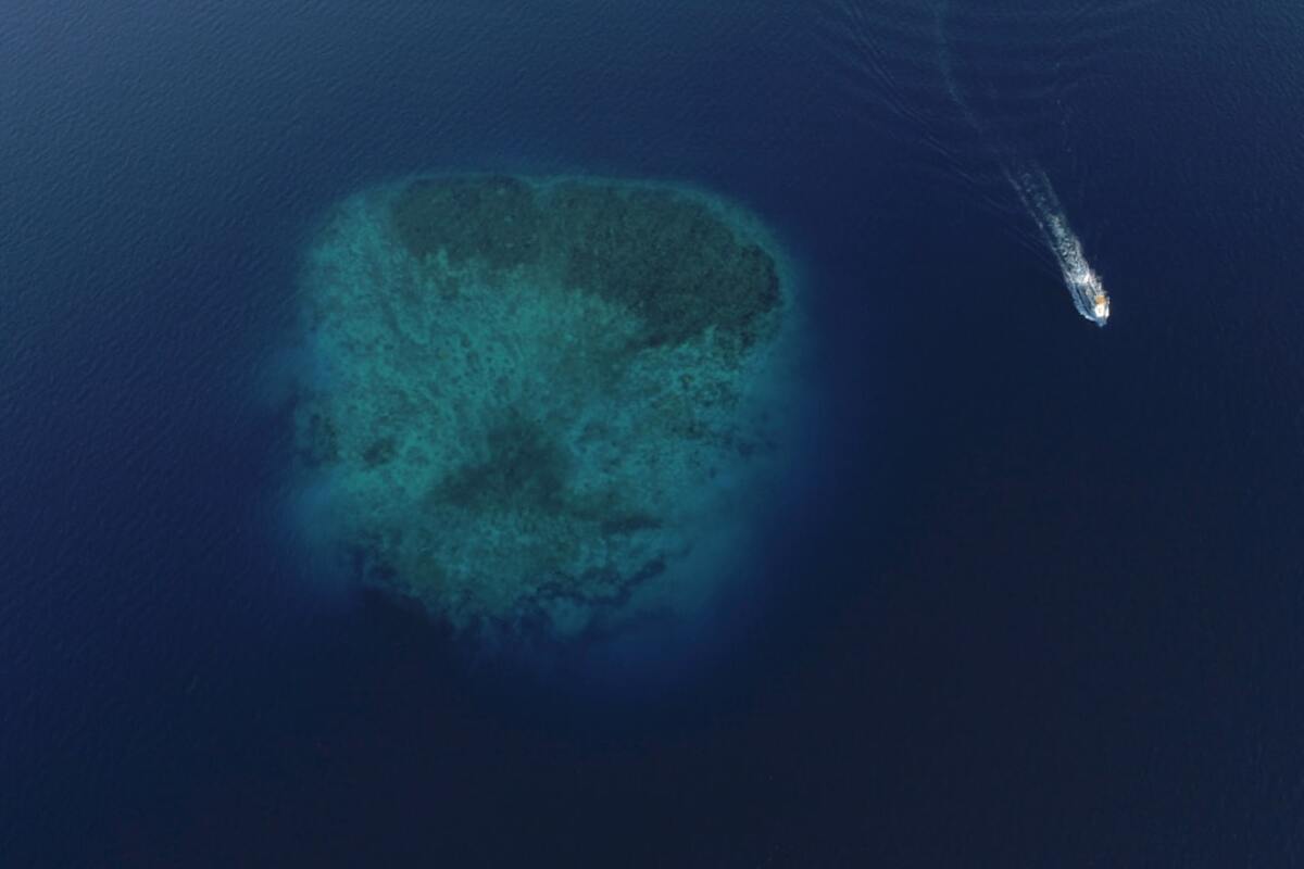
There are expeditions that feel like time travel. Not into the past, precisely, but into a future landscape suddenly thrust upon us. Approaching the Hunga Tonga–Hunga Ha'apai volcano months after its world‑shaping eruption, the charts we carried were already artifacts—out of date, outmatched by a seafloor that had been broken and remade in hours. The crew stepped into that uncertainty with a modest ship, compact instruments, and a plan that prized agility over grandeur.
The route in was scripted by weather, permits, and the unpredictability of a living caldera. We staged from a nearby harbor, where fishermen spoke of ash fall that turned the sea gray and of nights lit by distant lightning that was volcanic, not storm‑borne. Our objective was not to explain everything, but to capture the first durable signals: temperature shifts, turbidity pulses, and the earliest return of life at depth. The expedition had three phases—rim survey, descent and sensor deployment, and a cautious exit that left behind quiet observers ticking away in the dark.
Out on deck, the sea carried a memory of the blast. Floating pumice still drifted in rafts, mottling the surface like a strange winter. Beneath, multi‑beam echoes would soon sketch a caldera whose walls were scalloped and streaked by slides, with talus fans radiating toward a floor newly carpeted with ash. Even before instruments touched water, the first lesson of the expedition came from our own restraint: we were entering a place still rearranging itself, and the work would be guided by that humility.
We began with a slow perimeter trace around the suspected rim. The charted island that had once bridged two older cones was gone; in its place, swells shoaled over submerged high ground. Our skipper kept a steady 4 knots while the sonar drew a fresh outline, and the science lead marked zones where a remotely operated vehicle (ROV) could thread between outcrops to the caldera floor. The plan was to minimize anchor time, work off dynamic positioning, and deploy only what we could safely retrieve or leave responsibly.
As night arrived, a pale sheen drifted past the hull—microscopic glass shards that glinted in the work lights. We logged air and deck particulate counts and rotated the overnight watch. The ocean here was quiet, but not silent. It creaked. It hissed. Somewhere beneath, hydrothermal vents were reclaiming their voices.
| Phase | Objective | Key Tools | Time on Task |
|---|---|---|---|
| Rim Survey | Trace caldera outline, identify safe descent corridors | Multibeam, ADCP ping, drift nets | 14 hours |
| Descent & Deploy | ROV transects; seed moorings with sensors | ROV, CTD rosette, ash traps | 22 hours |
| Exit & Watch | Data offload; establish remote logging | Acoustic releases, satellite pings | 8 hours |
That first day set the tone. We were making a map, but the map was also making us: it forced decisions about route, speed, and where to spend limited daylight. In the control room, the sonar curtains parted to reveal slopes etched with fresh scars. The caldera was wider than some had expected, its rim irregular but coherent, the floor lying far below our keel—hundreds of meters, enough to press the water column into its own weather of temperature and density.
Descent: Sensors, sail and wire in the gray water
Morning brought a wind that calmed the surface and gave us our first window. We prepped the ROV on a short umbilical suited for tight work. Its camera lens wore a disposable sacrificial cover to guard against abrasive ash. The first descent followed a shoulder of the rim where bathymetry suggested a stepped route—down to a ledge, across, then down again.
ROV pilots know that the first meters are always the most deceptive: the surface glare, the bubbles, the sense of falling into air before the world turns blue. This descent turned gray. Suspended particles rocketed past like snow in a storm, then thinned to reveal a slope of pumice cobbles settling into place. The ROV’s lasers (set at a fixed 10‑centimeter spacing) painted their dots on stones that were featherweight yet hefty in number. A hermit crab skittered through the haze, then vanished as a cross‑current eddied up the ash.
We set three waypoints along the route and paused to sample water with the CTD rosette. Each stop yielded temperature, salinity, and turbidity profiles that we annotated in real time. We saw a sharp turbidity spike just below the thermocline, likely a layer where fine ash had been corralled by density differences. Farther down, the water cleared unexpectedly, a reminder that the caldera’s topography was already sorting the ash into basins and chutes.
At the second ledge we deployed the first mooring: a compact rig with a thermistor string, a turbidity logger, and an acoustic release. The anchor was a stack of small discs fused into a low‑profile mass that could be hoisted by the release without snagging. Above it, three ash traps—simple inverted cones with baffles—waited to catch whatever the sea chose to drop in the weeks ahead. We clipped on a time‑lapse camera with a wide view of an ash plain and a pressure gauge that would whisper depth ticks back to us by acoustic ping when asked.
Because wireless signals die quickly in seawater, we created a choreography of checks. Every deployment had a call‑and‑response with the deck acoustic modem. The ship hummed, the mooring answered, and the ROV filmed a final sweep before we moved on. None of this was glamorous, but each successful handshake felt like a tiny victory against the weight of water and the strangeness of a place with no reference points.
Midday, we launched a small autonomous surface vehicle to trace the rim under its own solar power. Its job was simple: zigzag along the caldera edge, log wave energy and surface temperature, and act as a breadcrumb for our ship when visibility dropped. On the screen its track drew a shallow scallop, curving around irregularities as though learning the caldera’s handwriting.
The second descent went deeper, angling into a chute that carried us across what looked like a dune field. Ripples of ash marched in low waves down the slope, aligned with a faint current. Life was sparse but present: a brittle star sprawled under a dusting that mimicked starlight; a pale sea cucumber wrote its slow cursive behind it. We paused to listen. The ROV’s hydrophone recorded a faint shimmer—soft crackles that might have been shrimp, or the murmur of micro‑vents where heat teased chemistry out of seawater.
By late day we had placed three moorings: one at the rim’s shoulder, one at mid‑slope, one on the caldera floor where the world went dim and the ash thickened into a powdery blanket. We worked small to think big—each node a whisper of data that, linked over time, could tell a story about settling particles, the return of oxygen, and the circulation that would either seal the ash in place or send it billowing back up the slopes.
- ROV transect length (total): approximately 3.6 km across three dives
- Moorings deployed: 3 (rim, mid‑slope, floor)
- CTD casts: 11, spaced to capture diel variability
- Ash traps: 9 total, 3 per mooring
On deck, the ash collected from the first drift nets came up fine as flour, with shards that sparkled under a hand lens. The lab bench became a gray galaxy. We photographed, sieved, and stowed what we could before a squall forced us to lash down and wait. The ocean has a way of collapsing big plans into small acts of care: tape this, tie that, check that O‑ring twice. The expedition’s most precious resource was not a gadget but time—the unbroken sequence of hours needed to make a clean, interpretable record of a place that refused to sit still for long.
What we learned: Ash, microbes, and a living caldera
People love the reveal—the map, the numbers, the headline. But in a newborn landscape, first results are less a chorus than a few clear notes. Still, those notes rang.
The turbidity profile we stitched from the CTD casts showed a layered ocean that was actively reorganizing itself. Near the rim, a mid‑depth turbidity lens drifted like a fog bank, waxing at night and thinning by late morning as currents sheared it away. At mid‑slope, the lens sank and sharpened, suggesting a sorting by grain size and density—a quiet physics lesson written in ash.
Temperature told a subtler tale. On the caldera floor, thermistors logged tiny, periodic lifts—warm pulses a fraction of a degree above the surrounding water. Taken alone, they were easy to dismiss. In sync with the ROV’s hydrophone, they hinted at gentle venting—breaths of water warmed below, rising and diffusing into the vastness above. If vents were speaking, they were whispering.
Life’s return was patchy, but unmistakable. The first day showed an austere scene; by the third, the ROV passed a lacy film on ash that looked like frost. Under magnification topside, that film resolved into microbial mats—early colonizers with a gift for turning chemical gradients into food. Where they draped the ash, the sediment’s surface firmed; where they were absent, a prop fin could still send up a roostertail of powder.
We had anticipated that pumice would act like seed rafts for life. In the traps and nets, we found more than we expected: tiny encrusting algae, larval bivalves clinging like passengers on a storm‑tossed ferry, and the beginning of a biofilm that would make otherwise inert glass part of the food web again. Recovery is not a straight line, but in these fragments was a reminder that the ocean seldom waits for our schedules.
The caldera itself behaved like a basin with a pulse. Acoustic Doppler Current Profiler (ADCP) data showed a gentle two‑layer circulation, with inflow near the floor and outflow higher up—effectively a conveyor that could trap fine ash below for months while letting smaller particles and dissolved nutrients leak out along the rim. That circulation matters for everything from water clarity to how quickly photosynthesis can resume near the surface.
Below is an at‑a‑glance snapshot of our lean toolkit—the working vocabulary of a compact expedition designed to leave a light footprint and a long record.
| Instrument | What it measured | Why it mattered |
|---|---|---|
| CTD Rosette | Conductivity, Temperature, Depth, Turbidity | Built the backbone water column profile; flagged ash lenses |
| ROV (short tether) | Video, stills, hydrophone, laser scaling | Mapped slopes, ground‑truthed sediment and life |
| Thermistor String | Micro‑temperature shifts at set depths | Detected faint venting pulses on the caldera floor |
| Ash Traps | Particle flux over time | Captured settling rates and grain size changes |
| ADCP | Current direction and speed | Revealed two‑layer circulation within the caldera |
There were surprises too, the kind that will take months to parse. One ash trap filled quickly, then slowed to a trickle; another, meters away, accumulated steadily as if plugged into a different sky. An overnight CTD cast at the rim recorded a brief oxygen dip without an obvious turbidity partner—perhaps a thin bloom of microbes that flickered and faded before dawn.
Critically, the expedition was as much about how to work here as what to find. We learned to read the ash like weather—feel when the ROV’s thrusters would fog the scene, time our descents to when currents were slack, and accept that some of the caldera would remain a blur until gravity and chemistry did their long work. Resilience here was practical: spare sacrificial lenses for cameras; redundant seals; flexible mooring designs that could be released without dragging across fragile slopes. We took only what we needed and left only timed, release‑ready gear.
On the last day, we circled the caldera at dawn. The autonomous surface vehicle pinged its final breadcrumb line, curving back into our orbit. The sea was calmer, the air cleaner. We pulled the ROV aboard, sluiced the ash from its joints, and stowed the rosette. The ship turned away from the rim and toward a horizon no longer tinted gray. Behind us, in the dark bowl of the caldera, small instruments hung quietly, counting and waiting.
We left not with closure but with a thread—data set to trickle in via acoustic release and satellite pings, pieces of a story bigger than any one expedition. Across the weeks to come, the moorings will hear whatever the volcano decides to say: the caldera’s settling sighs, the hush of ash finally finding its level, the first busy murmur of a food web knitting itself back together.
Safety is dynamic. We relied on updated bathymetry, local authority guidance, real‑time gas and particulate monitoring, conservative weather windows, and equipment that minimized seabed disturbance. We avoided anchoring on unstable slopes and maintained abort plans for every dive.
Safety is dynamic. We relied on updated bathymetry, local authority guidance, real‑time gas and particulate monitoring, conservative weather windows, and equipment that minimized seabed disturbance. We avoided anchoring on unstable slopes and maintained abort plans for every dive.
Fine ash remains in suspension, forming lenses that move with density layers and currents. Coarser grains settle into chutes and basins. Over time, biological processes bind ash into aggregates, hastening its fall. The caldera’s circulation can trap particles below while allowing dissolved nutrients to leak outward.
Fine ash remains in suspension, forming lenses that move with density layers and currents. Coarser grains settle into chutes and basins. Over time, biological processes bind ash into aggregates, hastening its fall. The caldera’s circulation can trap particles below while allowing dissolved nutrients to leak outward.
In a shifting seafloor, simplicity is resilience. Compact, redundant instruments can be deployed rapidly, released safely, and adjusted on the fly. A lean approach reduces footprint while capturing the essential signals needed to guide future, longer deployments.
In a shifting seafloor, simplicity is resilience. Compact, redundant instruments can be deployed rapidly, released safely, and adjusted on the fly. A lean approach reduces footprint while capturing the essential signals needed to guide future, longer deployments.